
What is BioBase?
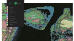
If you’re not familiar with our Center for Fisheries Technology partner BioBase, they provide satellite and sonar imagery tech and analysis for habitat mapping. BioBase is composed of two different products, EcoSound and EcoSat. Ecosat processes satellite imagery to create shallow vegetation and benthic habitat maps. While, EcoSound uses off-the-shelf sonar technology and automatic cloud... Read More